VIERNES 7 DE JULIO DE 2023

En el año 1973 se publicó en el siguiente informe…

«Additional information is presented on the steam plant at Myvatn and possible plant sites at Krafla and Námafjall are considered especially with regard to environmental implications. The Steam Plant at Myvatn has been operating under these conditions since 1969 and there have been no signs of thermal or chemical pollution in the surroundings, caused by the steam, but precipitation of silica from the thermal water has diminished the permeability of the lava into which the water is directed. The water thus flows consider­able distances in search of new and new swallow holes. This problem is not considered serious at the present stage, as the permeable lava field is fairly extensive, but the problem will, of course, increase with time and similarly if drilling will increase. Geothermal Power Plant at Námafjall or Krafla, the thermal water, which contains much more dissolved chemicals than the ground water,
produces a considerable stream from the plant, and it is certain that the dissolved silica will precipitate in the stream bed. The stream bed can be on the surface, or the stream may drain into the lava and mix with the ground water. The steam is ejected into the atmosphere where it disintegrates in a fairly limited area. As a power plant of this kind pollutes its surroundings, it is self evident that environmental considerations will be a big factor in the selection of a plant site. By utilizing these areas sensibly, i.e. by avoiding overexploiting the areas, the amount of thermal water mixing with the ground­ water should not increase significantly but mainly change in character from the natural situation.»

Geothermal POwer Station, Preliminary Project Report on a Power Station with regard to Development at námafjall or Krafla

En el informe anterior se especificaba que era importante que no se aumentara la explotación en energía geotérmica en la zona de Islandia debido a que era un tipo de energía a tomar en consideración con respecto a los efectos nocivos que provocaba en el medioambiente si no se controlaba. ¿Y qué ocurrió?…

«Following the oil price hikes of the 1970s, the government took the initiative in excluding oil from district heating, replacing it with geothermal energy, with the result that the share of geothermal energy increased from 43% in 1970 to the current level of about 90%.»

Geothermal Country Update for Iceland

«The first geothermal exploration was carried out in 1972-1974 and a major geothermal assessment was made in 1981-1984.»

THE THEISTAREYKIR GEOTHERMAL SYSTEM, NORTH EAST ICELAND: CASE HISTORY

¿Cuáles han sido las consecuencias a este aumento en la explotación de la energía geotérmica en Islandia?

«The owners of fishing rights in Laxá and Kráká rivers in North East Iceland have written a letter to the minister of the environment, asking for immediate government action to protect the ecosystem of Mývatn lake and Laxá river, according to the local newspaper Morgnublaðið. They argue the lake has been under enormous stress in recent decade, and that the unique plant and animal life of the lake are facing collapse if the authorities don’t react immediately:
“The Marimo, which is only found in one other location in the world, has disappeared from the bottom of the lake and the lake floor is best described as a barren desert.”

Fishermen and landowners worried pollution is killing Mývatn lake and Laxá river

En el año 2017 se publicó el siguiente informe…

«Formation of a steam cap at shallow levels in geothermal reservoirs may result in temporary increase in gas content of steam produced from shallow levels and causing an increase in GHG emission factors for the power plant. More project data are needed to allow better understanding of how GHG emissions from geothermal power plants evolve with time.
The effects of geothermal power production on diffuse CO2 emissions through soil are still not fully understood and may vary drastically in different types of geothermal systems. In Reykjanes, Iceland, diffuse CO2 emissions have increased fourfold from the commissioning of a 100 MW geothermal power plant in the field in 2006. Historical heat flow measurements from Wairakei, New Zealand, suggest that power production also resulted in increased CO2 emission through the soil in that field. In Larderello, Italy, the opposite occurred, i.e. geothermal power production has resulted in significant reduction of surface activity and thus GHG emissions through fumaroles and soil.
It is vital for the geothermal sector to have as complete understanding of the environmental impacts of geothermal power production as possible. This includes not only measuring GHG emission factors at the commissioning of power plants, but also understanding how GHG emission factors change over time and how power production affects GHG emissions through soil. It has become increasingly apparent in recent years that geothermal power plants can, in rare instances, release significant quantities of GHG into the atmosphere.»

Greenhouse Gas Emissions from Geothermal Power Production (february 2017)

En el informe publicado en el año 2017 por World Bank se decía que Islandia había aumentado considerablemente su potencial geotérmico a partir del año 2006. Quizás desconocían, o ellos sabrán, el informe publicado en el año 1973 en el que se aconsejaba NO AUMENTAR LA SOBREEXPLOTACIÓN DE ENERGÍA GEOTÉRMICA EN LA ISLA por sus terribles consecuencias para el medioambiente…

«The pollution danger far away from the power plants is significantly increased if the waste water follows a well defined path at depth. It should be mentioned that
there must be a considerable amount of thermal water and gases mixed with the local groundwater systems naturally in the Namafjall and Krafla thermal areas. By utilizing these areas sensibly, i.e. by avoiding overexploiting the areas, the amount of thermal water mixing with the ground­ water should not increase significantly but mainly change in character from the natural situation. It is considered likely that trace elements such as B and As are near the danger limit in the waste water,
according to the tolerance limits of WHO and USPHS, but the tolerance limits are given with respect to vegetation and living organisms in lakes.»

Geothermal POwer Station, Preliminary Project Report on a Power Station with regard to Development at Námafjall or Krafla (september 1973)

Es más, perforaron y perforaron como nunca antes lo habían hecho…

«Islandia parece que quiere llegar al centro de la tierra, porque ha perforado el pozo más profundo del mundo. Son 5.000 metros de viaje al centro de la Tierra en el corazón de un volcán para aprovechar la energía renovable del interior de nuestro planeta, cuya temperatura alcanza los 500ºC.
El proyecto se ha llevado a cabo gracias al trabajo conjunto de la petrolera noruega Statoil y The Iceland Deep Drilling Project (IDDP) en la península de Reykjanes, donde ese volcán hizo erupción hace 700 años. La perforación, que se inició en agosto del 2004, está a punto de finalizar con éxito.»

Islandia baja hasta los infiernos para generar energía (marzo 2017)

¿Y qué avisé en el año 2019?…

«Reto a los científicos:

NO VA A EXISTIR NINGUNA ERA GLACIAL

Vais a tener el infierno en la Tierra.»

(SueN K. GifT, Noviembre 2019)

No me equivocaba, porque se perforó el Planeta Tierra hasta buscar los infiernos que lo alimentan, es decir, el calor interno del mismo, para explotar la energía geotérmica que produce y dicen que «quien busca encuentra», así que, como buscasteis el infierno, el infierno es lo que habéis hallado…

«El 19 de marzo de 2021 el volcán islandés Fagradalsfjall entró en erupción y se mantuvo en actividad hasta diciembre del mismo año. La lava en erupción cambió con el tiempo; durante las fases iniciales de la actividad eruptiva, provenía predominantemente de cerca del Moho, pero durante las siguientes semanas su composición cambió, lo que indica que procedía de magmas generados a mayores profundidades.»

La erupción del volcán Fagradalsfjall arrojó datos inesperados
(septiembre 2022)

Porque habéis despertado volcanes dormidos, no ha sido algo natural, no, los habéis activado…

«Tras siglos de inactividad, la península islandesa de Reykjanes ha entrado en erupción dos veces en menos de un año, lanzando fuentes de roca incandescente. La última erupción, que comenzó a las 13:18 hora local del 3 de agosto, se abrió en una fisura a sólo unos cientos de metros del cono creado por el estallido volcánico del año pasado. Ha pasado menos de un año desde que la lava dejó de brotar de la península islandesa de Reykjanes tras el primer gran estallido volcánico de esta región en casi 800 años. Pero ahora la isla vuelve a sangrar roca fundida. El inicio de una nueva erupción tan poco tiempo después de la de 2021 parece subrayar que esta península, antes tranquila y dormida, ha despertado de su largo letargo.
Esto podría anunciar el comienzo de décadas de erupciones ocasionales, dice Dave McGarvie, vulcanólogo de la Universidad de Lancaster (Reino Unido).»

La erupción de Islandia confirma varias teorías de los científicos y abre nuevas incógnitas (agosto 2022)

Y no sólo habéis despertado volcanes inactivos sino que también habéis provocado terremotos que han destruido ciudades…

«El terremoto que destruyó la ciudad surcoreana de Pohang el 15 de noviembre de 2017 tuvo su origen en una operación en la planta geotérmica experimental de la región. El panel de expertos del gobierno de Corea del Sur ha concluido que todas las evidencias llevan a pensar que fue la inyección de fluídos a alta presión en la roca (fraking) la que desató el sismo. A diferencia de las plantas geotérmicas convencionales, que extraen energía directamente de agua o roca subterránea caliente, la central eléctrica rompe la rocapara liberar calor. Esta tecnología se conoce como sistema geotérmico mejorado.»

Corea admite que una planta geotérmica causó el devastador terremoto de 2017 (marzo 2019)

En febrero de 2017, World Bank publicó…

«It is vital for the geothermal sector to have as complete understanding of the environmental impacts of geothermal power production as possible. This includes not only measuring GHG emission factors at the commissioning of power plants, but also understanding how GHG emission factors change over time and how power production affects GHG emissions through soil. The World Bank and other Multilateral Development Banks are increasingly paying attention to these issues. The World Bank has recently developed a scheme to estimate, ex ante, GHG emission factors from geothermal power projects financed by the institution. The World Bank is encouraging developers that benefit from World Bank financing to collect project data that will allow improved understanding of these issues. The geothermal sector, as a whole, is encouraged to collect and publish more data that will improve the collective understanding of GHG
emissions from geothermal power production and the underlying processes.»

Greenhouse Gas Emissions from Geothermal Power Production (february 2017)

En noviembre de 2017 ocurrió el terremoto que devastó una ciudad en Corea del Sur debido a la sobreexplotación de la energía geotérmica

«The moment magnitude (Mw) 5.5 earthquake that struck South Korea in November 2017 was one of the largest and most damaging events in that country over the past century. Its proximity to an enhanced geothermal system site, where high-pressure hydraulic injection had been performed during the previous 2 years, raises the possibility that this earthquake was anthropogenic. We have combined seismological and geodetic analyses to characterize the mainshock and its largest aftershocks, constrain the geometry of this seismic sequence, and shed light on its causal factors. According to our analysis, it seems plausible that the occurrence of this earthquake was influenced by the aforementioned industrial activities. Finally, we found that the earthquake transferred static stress to larger nearby faults, potentially increasing the seismic hazard in the area.»

The November 2017 Mw 5.5 Pohang earthquake: A possible case of induced seismicity in South Korea

No sólo es peligrosa la sobreexplotación de la energía geotérmica por las consecuencias tanto en el inicio del proyecto como en el transcurso del proyecto sino que también lo es en costos…

«The energy ministry will also carry out a thorough inspection in the process of pursuing its project to commercialize geothermal power plants and to select suitable sites to house such plants. In addition, the energy ministry said that starting from this year, it will spend nearly 226 billion won over the next five years to repair houses and infrastructure in the town of Heunghae in Pohang, which suffered the biggest blow from the 2017 quake.»

Geothermal Power Plants Triggered 2017 Pohang Quake

¿Realmente es seguro y rentable invertir en centrales geotérmicas? El coste económico de reparación por el terremoto en Pohang es de unos 160 millones de euros. Lo curioso del tema es que este hecho quedó como olvidado ya que, desde entonces, World Bank y el resto de países han invertido en energía geotérmica más que nunca…

«El GGDP (Global Geothermal Development Plan) ya está comprometido con la mayoría de los países donde este oleoducto está activo y muchos de ellos ahora han desarrollado la capacidad y la experiencia para desarrollar aún más sus recursos geotérmicos. El GGDP a través del nuevo programa ESMAP aprobado en junio de 2020 («Programa de Desarrollo de Electricidad Geotérmica ESMAP») continuará apoyando la energía geotérmica como una alternativa limpia a los combustibles convencionales en pie de igualdad con otras energías renovables en estos países.
El interés del cliente del Banco Mundial y del donante de ESMAP, ha proporcionado un impulso adicional para el establecimiento de un nuevo programa ESMAP en 2020 que centra el GGDP en el uso directo geotérmico específicamente («Programa de Desarrollo de Uso Directo Geotérmico»). Los beneficiarios finales del GGDP son los países clientes del Banco Mundial con recursos geotérmicos.»

El Plan Global de Desarrollo Geotérmico (noviembre 2020)

Es decir, 3 años después del suceso en Pohang, World Bank apostó más que nunca por la energía geotérmica, ignorando lo que ocurrió en Corea del Sur, y lo hizo, entre otras zonas del Planeta, en Turquía

«With the Risk Sharing Mechanism provided by the World Bank’s Clean Technology Fund, the Grant Investment Mechanism supports investments in geothermal fields by partially meeting the risks of geothermal energy investors in exploration and verification drilling activities. All investors with exploration licenses can apply to the Risk Sharing Mechanism Project to benefit from geothermal energy for electricity generation and heat use.»

Turkey’s Development and Investment Bank TKB has announced its continued work and support of the Risk Mitigation scheme for geothermal development in Turkey (supported by the World Bank), with a second round of applications to open in May 2020 (febrero 2020)

¿Y qué ha ocurrido en Turquía que guarda relación con lo ocurrido en Corea del Sur? Un devastador terremoto. Aquí la cuestión sería que los expertos, así como el gobierno turco, realizaran una investigación exhaustiva de si el terremoto ocurrido inicialmente en Turquía, y luego en Siria, a principios del año 2023, tuvo como causa un origen natural o más bien un origen no tan natural, ya que…

«Turkish Geothermal Energy Market has seen an incredible growth from 30 MWe installed power generation capacity in 2008 to 1.676 MWe as of 2022. No other country has shown such an incredible fast and sustainable growth of its geothermal sector as Turkey has over the past decade.»

5th International Geothermal Energy Congress & Exhibition (september 2022)

En la publicación anterior se especifica un gran aumento en la producción de energía geotérmica, en Turquía, justamente en el año 2022. ¿Qué ocurrió en el año 2022 en Turquía que no había ocurrido antes?…

«Sólo en el año 2022, Turquía registró más de 20.000 seísmos. De ellos, casi 130 superaron la magnitud 4 en la escala de Richter, mientras que uno superó el nivel 6, según datos de la agencia nacional de emergencias (AFAD) recogidos por los medios turcos.»

Turquía, un país proclive a terremotos por su ubicación entre placas tectónicas (febrero 2023)

Turquía es proclive a terremotos pero nunca antes habían habido tantos sismos en un mismo año, con lo cual, algo no iba bien…

«El país organizó en noviembre de 2022 y por primera vez un simulacro de seísmo a nivel nacional que se extendió de forma simultánea por 81 provincias.»

Turquía, un país proclive a terremotos por su ubicación entre placas tectónicas (febrero 2023)

Es más, Siria no había sufrido sismos en décadas…

«Durante los últimos 50 años no hay precedentes en Siria de un terremoto que haya causado tantas víctimas y daños como el registrado hoy.»

Turquía, un país proclive a terremotos por su ubicación entre placas tectónicas (febrero 2023)

Parece que haya una especie de carrera en el Planeta Tierra por ver quién consigue generar más hegemonía energética…

«The surface of greenhouses heated with geothermal energy in Turkey increased by 400% since 2002, according to Mücahit Kıvrak from the Balıkesir University. The country has more than 500 hectares in such facilities, compared to the world total of 1,500 hectares. Turkey is one of the superpowers in geothermal power with 1.68 GW of installed capacity in 2021. It came in fourth, behind the United States, Indonesia and the Philippines, according to the International Renewable Energy Agency, which registered an overall 15.64 GW. But it is holding the first place in the world in geothermal energy used in greenhouses, Turkish officials say.»

Turkey accounts for one third of world’s geothermal greenhouses (august 2022)

Y no sólo hay una especie de carrera entre países mundiales por explotar recursos energéticos, sin importar las consecuencias de ello porque, si importaran, no tendríamos zonas de agua dulce contaminadas como nunca antes, ni extraños sismos y socavones que han aparecido en la última década, como nunca antes, sino que evaden los avisos que han ocurrido con respecto a explotar la energía geotérmica, invirtiendo más y más en este tipo de industria. Porque no sólo hubo problemas en Corea del Sur, no, en Francia tuvieron que detener un proyecto geotérmico…

«Las perforaciones han producido temblores de tierra y provocado el pánico de la población. Los seísmos dan al traste con el proyecto emblemático de la energía geotérmica en Francia.  Una central geotérmica, construida al norte de Estrasburgo, nunca verá la luz. Una orden del prefecto de la región de Alsacia la condenó tras una serie de terremotos que han conmocionado a la población. El último, de magnitud 3,5 en la escala de Richter, fue el 4 de diciembre.
«Primero sentimos una gran explosión y luego temblores muy perceptibles que duraron varios segundos», explica Martial Schillinger, concejal de La Wantzenau. Resulta que es un terremoto producido por la actividad industrial, o sea por la actividad humana relacionada con este pozo de descarga de la perforación de la empresa Fonroche», señala Michèle Kannengieser, alcaldesa de La Wantzenau. Ya en 2006, un proyecto similar tuvo que ser detenido por las mismas razones, a 135 kilómetros de aquí, en Basilea, Suiza.»

Suspendido el proyecto emblemático de la energía geotérmica en Francia (diciembre 2020)

El proyecto geotérmico detenido en Basilea, Suiza, demostró que este tipo de perforaciones provoca enormes cantidades de sismos…

«Agujerear la tierra para obtener calor de su interior puede causar pequeños seísmos capaces de provocar cuantiosos daños en la superficie. Esta es la conclusión de un estudio llevado a cabo en Suiza y cuya consecuencia ha sido la suspensión definitiva de las perforaciones geotérmicas cerca de Basilea por riesgo cierto de terremotos. Su decisión se basa en que el proyecto Deep Heat Mining podría provocar alrededor de 200 temblores con una magnitud media de 4,5. De hecho, los movimientos de tierra de magnitud 4,4 en 2006 fueron provocados por haber taladrado cinco kilómetros de profundidad para extraer agua a 160 grados de temperatura, cuyo vapor movería una turbina. Desde aquel año, la región ha sufrido 3.500 temblores de tierra, según los medios locales. El problema es que se trata de geotermia con perforaciones de más de cinco kilómetros de profundidad’, avisa el geólogo Manel Prada. ‘Eso significa que el agua o el gas que se inyecte puede afectar a las estructuras internas y activarlas, sobre todo en zonas sensibles a sismicidad como Suiza’.»

Las plantas geotérmicas causan riesgo sísmico (febrero 2010)

Creo que el estudiar durante años en este Planeta no importa en absoluto cuando de grandes inversiones capitalistas hablamos. Un geólogo, Manel Prada, en el año 2010, ya avisó de la problemática al inyectar agua para crear pozos geotérmicos. No creo que haya sido el único en avisar pero, cuando las grandes empresas inyectan, no sólo agua para perforar La Tierra, sino grandes cantidades de dinero, lo único que importa es el enorme beneficio económico que ellos, no los afectados, van a recibir…

«Los planes suizos para obtener energía del interior de la tierra han tenido el mismo destino que la planta geotérmica del norte de California, a unos 160 kilómetros al norte de San Francisco, otra zona del planeta altamente sensible a terremotos.

Una instalación en EEUU afecta a las fallas de California: Las instalaciones, operadas por la compañía Alta Rock Energy, en una zona conocida como The Geysers, están paralizadas desde septiembre a consecuencia de problemas con los perforadores (no alcanzaron la profundidad adecuada) y porque están siendo examinadas por el Departamento de Energía, que financió esta perforación con seis millones de dólares. Un duro revés para la compañía en la que, según The New York Times, Google había colaborado con 30 millones de dólares. Según un comunicado de la compañía, ‘taladrar la tierra tiene riesgos’, sobre todo en la zona de The Geysers, donde el subsuelo podría deshacerse a consecuencia de la inyección de agua. Pero a pesar de estos cierres, los expertos consideran la energía geotérmica como una alternativa válida al calentamiento global para sustituir a los combustibles fósiles. El Departamento de Energía de EEUU trabaja en un ambicioso plan en el que ha invertido 400 millones de dólares sólo en 2009. Los Estados de Idaho, Nevada y California ya cuentan con proyectos financiados.»

Las plantas geotérmicas causan riesgo sísmico (febrero 2010)

No importa lo que los científicos y los profesionales en geología, perforación y este tipo de industria, la geotérmica, demuestren, no importa porque, a pesar de la cantidad de problemas que se han demostrado con la perforación e inyección de agua en la corteza y el manto terrestre, este tipo de industria ha continuado realizándose, todavía más si cabe…

«Además de una subvención de 6 millones de dólares del Departamento de Energía, AltaRock había atraído unos 30 millones de dólares de capital de riesgo de inversores de alto perfil como Google, Khosla Ventures y Kleiner Perkins Caufield & Byers. Algunas de estas empresas emergentes se pusieron al frente y convencieron a algunos capitalistas de riesgo de que estaban muy cerca del despliegue comercial», dijo Daniel P. Schrag, profesor de geología y director del Centro para el Medio Ambiente de la Universidad de Harvard. Los entusiastas de la geotermia afirmaron que la perforación de millas en roca dura, como lo requiere la técnica, podría hacerse de forma rápida y económica con pequeñas mejoras en los métodos existentes, dijo el profesor Schrag. «Lo que hemos descubierto es que es más difícil hacer esas mejoras de lo que algunas personas creían», agregó.»

Se cierra el proyecto geotérmico en California (diciembre 2009)

Claro está en que si una empresa avisa que un proyecto industrial no es viable, además de ser contraproducente, pero los inversores están decididos a invertir en ese tipo de industria, lo que prevalecerá serán los intereses capitalistas, es lo que ocurre en este Planeta. Y no importa si se alcanzan profundidades críticas en zonas del Planeta que se hallan sobre fallas tectónicas muy importantes, no importa…

«La perforación del pozo volcánico comenzó en agosto de 2016, después de que geólogos e ingenieros descubrieran la presencia en esta zona de fluido supercrítico que podría ser utilizado para una producción eficiente de energía. La perforación en esta zona volcánica has sido complicada y ha requerido diversas adaptaciones de los sistemas de control y de los taladros para conseguir superar las diversas capas de rocas y mantener la dirección de perforación deseada. “Necesitaríamos 30 a 35 pozos geotermales convencionales mientras que, si alcanzamos fluido supercrítico, sería suficiente con entre tres y cinco pozos”, calcula Albertsson.»

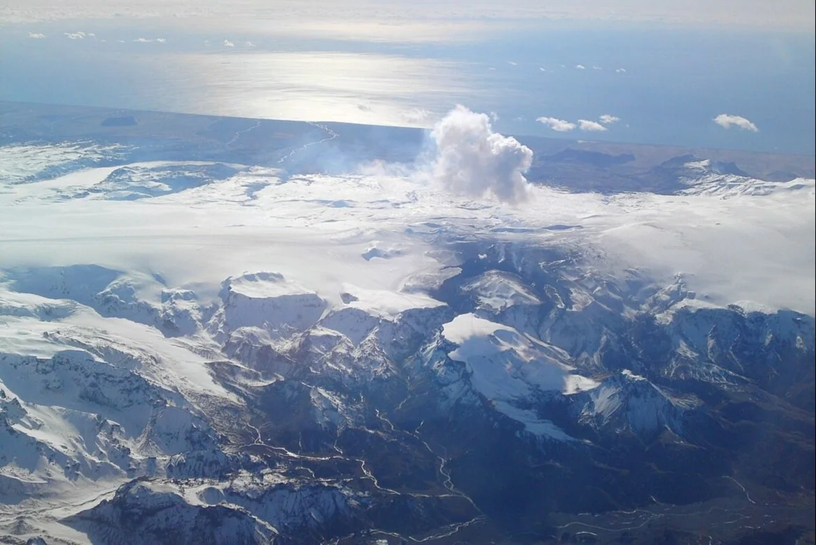
Islandia perfora el ‘corazón’ de un volcán y se acerca a la independencia energética (mayo 2017)

¿Y qué es el fluido supercrítico?…

«Un fluido supercrítico es cualquier sustancia a una temperatura y presión por arriba de su punto crítico. Esos fluidos pueden difundirse a través de sólidos como si fueran un gas y disolver materiales como un líquido.»

¿Y qué está ocurriendo en el Planeta Tierra desde que se inició el siglo XXI?

«Según un nuevo estudio publicado en Geophysical Research Letters, la distribución del agua en el planeta afecta cómo se distribuye la masa. Los investigadores identificaron la capacidad del agua para cambiar la rotación de la Tierra en 2016, y solo hasta ahora se exploró la contribución de la extracción del agua en los cambios.»

La Tierra se ha inclinado 80 centímetros a causa de la extracción de agua
(julio 2023)

¿Sabéis cómo funciona una sauna a vapor? Funciona arrojando agua, cuanto más fría mejor, sobre una piedras volcánicas muy calientes. Al hacer esto el agua se convierte en vapor, un vapor que puede llegar a provocar graves quemaduras si no se mantiene una distancia prudencial. En una superficie tan inmensa como es el manto terrestre, perforar éste para inyectar agua fría y así provocar una enorme y potente fuente de energía a vapor que satisfaga a la industria energética (energía geotérmica) no evita que esa energía en forma de vapor se traslade a otras zonas de la corteza terrestre. Es decir…

«El ir en busca de fluidos supercríticos para obtener mayor cantidad de energía, perforando a niveles mucho más profundos que antes, provoca que el potencial energético del Planeta Tierra emerja al exterior. Es decir, toda la toxicidad y toda la energía radiactiva que existe en la corteza terrestre, porque existe radiactividad en el interior de nuestro Planeta, la estáis liberando en forma de vapor ardiente que se filtra por los túneles y ríos subterráneos provocando acidez y aumento muy considerable de la temperatura en La Tierra. Esta es la principal causa por la cual los cultivos y las cuencas hidrográficas se están secando, esta es la principal causa por la cual el Planeta Tierra se está deshidratando, esta es la principal causa por la cual el eje gravitatorio de La Tierra ha sufrido cambios.»

SUEN K. GIFT

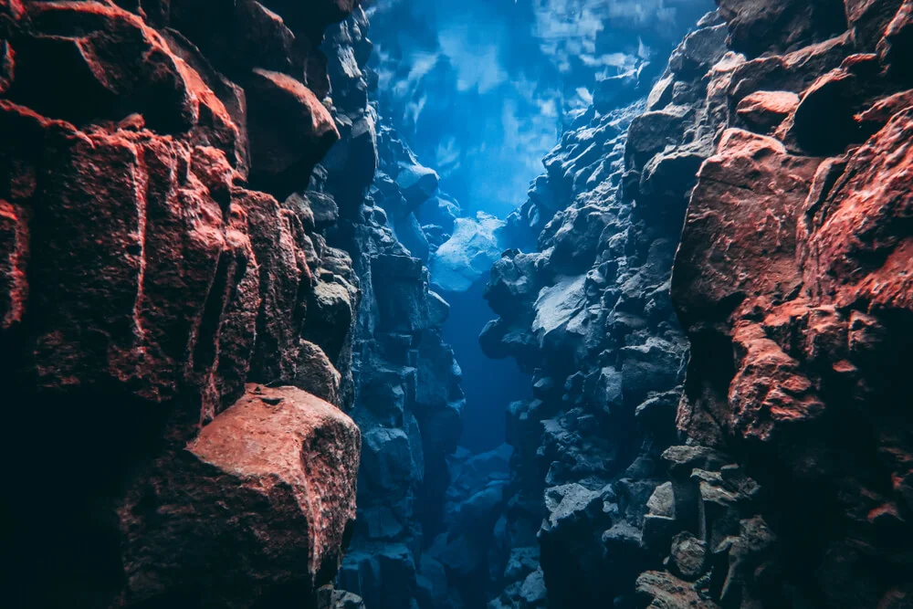
Habéis ocultado la verdadera causa de lo que está ocurriendo en el Planeta Tierra. El que perforarais tan, tan profundamente en Islandia, donde se halla la Falla de Silfra, ha provocado graves cambios estructurales en el resto del Planeta, porque La Tierra está completamente conectada. Todas las fallas, placas, volcanes, cuencas hidrográficas, océanos, ríos, montañas… todos ellos están activamente conectados. Sí se desequilibra de manera trascendental uno de ellos existe una reacción en cadena. Fijaros qué se descubrió en el año 2004…

«In July 2004, while exploring at a depth of 2,082 meters (6,831 feet) during an expedition along the northern Mid-Atlantic Ridge, scientists discovered several sets of these holes.»

The Case of the Mysterious Holes on the Seafloor (July 2022)

¿Qué tiene que ver Islandia con la aparición de misteriosos agujeros en el fondo marino? En Islandia se halla la Falla de Silfra, la cual es una fractura de la corteza terrestre que tiene desplazamiento y donde se localiza la división de las placas tectónicas Euroasiática y Norteamericana. El descubrimiento de los misteriosos agujeros ocurrió en el año 2004 en la zona norte de la dorsal mesoatlántica. Esta dorsal confluye en el centro de Islandia y ¿qué ocurrió a principios del siglo XXI en Islandia que puede haber provocado estos misteriosos agujeros?…

«The major energy companies of Iceland initiated the Iceland Deep Drilling Project (IDDP) to investigate the deeper levels of hydrothermal systems and determine if utilizing supercritical fluids could increase power production from such wells by a factor of 5-10 relative to that from conventional geothermal wells. The primary objective of IDDP is to find >450°C supercritical geothermal fluids at drillable depths, and to study their physical and chemical nature and energy potential. The IDDP was launched in 2000 by Deep Vision, a consortium of Icelandic energy companies (Hitaveita Sudurnesja Ltd., Landsvirkjun, Orkuveita Reykjavikur and Orkustofnun) (Fridleifsson and Albertsson, 2000). The principal aim is to enhance the economics of high temperature geothermal resources. A two-year long feasibility study was completed in 2003, dealing with geosciences and site selection, drilling techniques and fluid handling and evaluation. In November 2003, based on the findings of this report, Deep Vision decided to proceed to the operational stage and to seek international partners.»

The Iceland Deep Drilling Project – Scientific Opportunities (april 2005)

Qué casualidad que justo cuando perforan en Islandia para investigar acerca de los fluidos supercríticos aparecen, poco tiempo después, unos misteriosos agujeros en la dorsal mesoatlántica. Fijaros en la siguiente información…

«Implications for mid-ocean ridge environments: The Reykjanes ridge is the portion of the Mid-Atlantic Ridge (MAR) that extends onshore in southwest Iceland, where the subaerial location of the Reykjanes Peninsula allows investigation of the deep structure of the volcanic/hydrothermal system of a slow spreading mid-ocean ridge. However, the enhanced magma productivity from the Iceland hotspot has produced thicker crust at the Reykjanes ridge than is typical for the Mid-Atlantic Ridge.»

The Iceland Deep Drilling Project at Reykjanes: Drilling into the root zone of a black smoker analog (august 2018)

En la publicación anterior se especifica: «However, the enhanced magma productivity from the Iceland hotspot has produced thicker crust at the Reykjanes ridge than is typical for the Mid-Atlantic Ridge.» ¿Y qué ocurre con las corrientes de convección en el Planeta Tierra?

«Las corrientes de convección son el resultado de un calentamiento por gradientes de temperatura. Los materiales cálidos son más ligeros, por lo que suben, mientras que los materiales fríos son más pesados (más densos) y por lo tanto se hunden.»

VISIONERWRITER: «LO QUE NO TE HAN CONTADO PORQUE NO INTERESA Y ES EL MAYOR PROBLEMA EN LA PRÓXIMA DÉCADA… PARTE II.- EL ASESINATO OCULTO A LA TIERRA.» suen k. gift

¿Qué significa que hayan aparecido esos misteriosos agujeros en el fondo marino atlántico? Significa que se está extrayendo el calor del interior de La Tierra hacia el exterior, cuando es el interior del Planeta Tierra el que necesita estar a mayor temperatura que el exterior, con lo que se está provocando una enorme desestabilización gravitacional planetaria que DE NO SER DETENIDA CUANTO ANTES SERÁ TREMENDAMENTE CATASTRÓFICA. Significa que la zona de la dorsal atlántica se está fracturando más de lo normal porque se le está restando calor, se está hundiendo, se está separando más de lo que debería y eso está repercutiendo en el resto de océanos. Es lo peor que podríais hacer y lo habéis hecho. Os voy a mostrar más CASUALIDADES relacionadas con las recientes inversiones en energía geotérmica

«In 2003 GoI issued Geothermal Law that changed the regime of geothermal management in Indonesia. This law strengthens the Presidential Decree 76/2000 which provided more flexibility to all businesses to strive in the field of geothermal energy through an auction process before getting Geothermal Mining Permit (IUP=Ijin Usaha Pertambangan). In addition, this Law authorizes local government to have an active role and opportunities to issue permits, guidance and supervision to manage geothermal resources (the spirit of regional autonomy). The Law also gives powers to the Central Government and Local Government do the preliminary survey to exploration drilling. The data obtained is then used as the basis for setting Geothermal Working Area (GWA). This GWA then used in the auction by either the Central Government or Local Government. After the enactment of Geothermal Law, Government has issued 35 GWA, while earlier this law, government issued as much as 19 GWA. Total GWA issued by the Government till now are 54 GWA of the total 276 geothermal hotspots. And there are 7 of the 54 GWA were already in production (Table II) and those all are issued before the Geothermal Law. While the reserved of the new GWA (35 GWA issued after Geothermal Law) are 4,100 MW and all are not produced yet.»

Geothermal Energy Development in Indonesia:
Progress, Challenges and Prospect (2014)

En el año 2003 el gobierno de Indonesia apostó por la energía geotérmica

«A review of geothermal licensing occurred during the 4th decade. The Ministry (MEMR) together with regional governments were assigned the role of issuing new
licenses (WKP) through a bidding and control process (Law 27/2003). This attracted private developers. Exploration of Banda Arc Islands projects involved mainly VSI and PLN groups. By the end of 2010, a total of c. 55 geothermal prospects had been explored by ground surveys and c. 20 prospects had been tested by deep exploratory drilling. The installed capacity of seven developed Indonesia.»

HISTORY OF GEOTHERMAL EXPLORATION IN INDONESIA (1970-2010) (november 2014)

Es curioso que, justamente cuando el gobierno de Indonesia permite más inversión en energía geotérmica, justo en la zona que se menciona Banda of Arc Islands, en el artículo HISTORY OF GEOTHERMAL EXPLORATION IN INDONESIA (1970-2010), ocurriera uno de los terremotos más mortales en la Historia de la Humanidad…

«El 26 de diciembre de 2004 un terremoto de 9,1 provocó el mayor tsunami del siglo XXI y el más devastador al que la humanidad se haya enfrentado jamás.»

El tsunami de 2004 en el Índico: el más devastador de la historia

En Iran, a principios del siglo XXI, se investigó también en energía geotérmica

«Although there are many potential geothermal reservoir sites in Iran, reconnaissance measurements have scarcely been carried out so far. Geothermal heat flux is one of the main parameters to be investigated in geothermal exploration. The crustal field model of MF5 has been used in this study to estimate the Curie temperature depths of Kerman region in Iran. The magnetic field models of MF series focus on the lithospheric field. The initial model of MF1 was only determined from scalar data, acquired during the first year of the CHAMP mission (Maus et al., 2002).»

Reconnaissance exploration of potential geothermal sites in Kerman province, using Curie depth calculations (february 2015)

«Despite of suitable geological conditions and presence of many potential for geothermal energy productivity in Iran, due to lacking of high-tech instrumentation in the field of drilling, reservoir engineering and power plants construction and also due to existence of huge reservoir of oil and natural gas and cheap expenditures for energy productivity from them Iran is located at the earlier steps of this technique. On the other hand because of new policies in the government for changing the resources of energy production for domestic demands and also regarding to environmental laws, nowadays it can be seen that several organizations are working for exploration and exploitation of renewable energy resources, Ministry of energy, Center for Renewable Energy Research and Application (CRERA) and Geological Survey of Iran are among the main ones. Following report is prepared as a summary of recent activities about Geothermal Energy in Iran.»

GENERAL REPORT ON GEOTHERMAL AND RELATED FIELDS IN IRAN (2002)

La ciudad de Kerman, en Irán, registró un terremoto en el año 2003, cuando nunca antes había ocurrido en esa zona…

«The Bam earthquake occurred in an area without any historically recorded major earthquake.»

Seismicity anomalies of the 2003 Bam, Iran earthquake

Kerman se halla rodeada de zonas con alto potencial geotérmico, lo mismo que ocurre con la provincia de Hamadan, también en Irán, la cual ha registrado, como está ocurriendo en otras zonas del Planeta desde hace unos años, un enorme socavón…

«A giant sinkhole about 60 metres deep has made a surprise appearance in western Iran. The sinkhole opened up on August 19 near the small village of Kerdabad, in the Kabudrahang county of the western province of Hamadan. It has terrified both locals and experts, who say this phenomenon shows that groundwater tables have been badly damaged. The images of this giant hole in the earth are even more chilling due to its location: the sinkhole is only one kilometre from a village with more than 2,000 residents, and only a few more kilometres from a solar power station, a thermal power plant and a major national highway.»

A giant sinkhole opens up in drought-hit Iran (september 2018)

Tanto el anómalo terremoto ocurrido en Kerman en el año 2003 como el socavón ocurrido en Kerdabad en el año 2018 son únicos, no habían ocurrido anteriormente. Kerman y Kerdabad se hallan en una zona con depósitos hidrotermales y cinturones volcánicos, rodeados de zonas con potencial geotérmico. Fijaros en lo siguiente…

«The present study was carried out to assess the hydrogeochemical composition of the Suleymanli (Kahramanmaras, Turkey) thermomineral springs. The springs issue along fault zones and their temperatures ranks between 40 and 45 oC and they are classified as hot water.»

Hydrogeochemical Characteristics of the Suleymanli Thermomineral Waters, Kahramanmaras, Turkey (2009

Después del terremoto de Turquía, a principios del año 2023, en una de las zonas afectadas aparecieron vapores termales…

«Hot spring water that flowed out of a citizen’s backyard in the Sariz district of central Kayseri province after the Feb. 6 tremors, which caused widespread destruction and seismic changes in southern Turkiye, has the potential to be a center of thermal tourism, said Adnan Evsen, a geological engineer and member of the Kayseri branch of the Turkish Red Crescent (Kızılay). We witnessed the emanation of water vapors from the hot water flow in the garden of a citizen’s house in the Kızılpınar neighborhood of Kayseri. After conducting research, it was determined that this spring water was unearthed by seismic activities in the aftermath of the twin earthquakes. Fortunately, the area is not on the active fault line, which is a positive sign as it can contribute to the development of this region with its geothermal potential,» Evsen said.»

Quake-induced hot spring to draw thermal tourism to Türkiye’s Kayseri
(may 2023)

Meses antes del terremoto de Japón del año 2011, una zona geotérmica dio indicios de que algo no iba bien…

«The Onikobe single-flash steam turbine geothermal power plant in Japan has been supplying electricity to the grid for 36 years. Power station output has increased over the years and reached 15 MWe (gross) in February 2010. Numerous natural geothermal manifestations were present in the field prior to development. New fumaroles accompanied by hot liquid discharges spontaneously appeared near Well 128 on 8 September 2010. Such spontaneous features had frequently appeared in the past. The new features were monitored carefully – the manifestations intensified abruptly on 8 October, and engulfed Well 128 the same day. The fumaroles continued to grow until a large scale steam explosion occurred on 17 October 2010. A crater-lake formed and the Well 128 wellhead became submerged in hot water. After the steam explosion, steam and water continued flowing from the crater-lake. Fluid sampling was per- formed using a radio-controlled helicopter, and results of the chemical analysis of the fluid showed that the fluid in the crater was identical to production well 128 fluid. This suggests that Well 128 was damaged by the steam explosion incident, and that the residual flow from the crater-lake afterwards could be due to a casing failure in Well 128. This paper describes the sequence of crater-lake events and relief well drilling which finally succeeded in killing and plugging Well 128.»

Geothermal relief Well at the Onikobe Geothermal Power station (2013)

¿Y qué ocurrió en el año 2011?

«El terremoto y maremoto de Japón de 2011, denominado oficialmente por la Agencia Meteorológica de Japón como el terremoto de la costa del Pacífico en la región de Tōhoku de 2011 o gran terremoto de Japón oriental del 11 de marzo de 2011, fue un terremoto de magnitud 9,1,​ que creó olas de maremoto de hasta 40,5 m. El terremoto ocurrió a las 14:46:23, hora local (05:46:23 UTC), del viernes, 11 de marzo de 2011. El epicentro del terremoto se ubicó en el mar, frente a la costa de Honshu, 130 km al este de Sendai, en la prefectura de Miyagi, Japón, a una profundidad de 29.9 km.»

El devastador terremoto tuvo, como epicentro, la costa de Honshu, en la prefectura de Miyagi y la planta geotérmica de Onikobe se halla en la prefectura de Miyagi. ¿Qué más ocurrió en esa época?

«The Japanese Government has set the target to be 12,200 GWh (1.35% of total electricity) by 2010 and 16,000 GWh (1.65% of total) by 2014.»

2010 Country Update for Japan (april 2010)

«Japan’s Ministry of the Environment (MOE) released the results of a survey on November 13, 2012, on the installation of geothermal heat pump systems in the country. According to the report, the number of heat pumps installed in 2011 totaled 207, up 43 percent from 145 in 2010, when the number grew by 25 percent from the previous year. The survey revealed that the number of systems installed has been sharply increasing in recent years, as this system is one of the effective measures for saving energy as well as for mitigating heat island phenomenon.»

Japan Reports 2011 Geothermal Heat Pump Installations Up 43% from 2010

«The number of geothermal power plants in Japan has quadrupled since the 2011 nuclear disaster in Fukushima, northeastern Japan, according to industry data.»

Geothermal power plants in Japan quadruple since 2011 nuke accident
(november 2021)

Os voy a mostrar cómo existe una relación entre el aumento de centrales geotérmicas y el aumento de sismos en las zonas cercanas a esas centrales…

«The installed geothermal generation capacity in Japan was 312.3MW as of 1 January 1995. Yamagawa, Sumikawa and Yanaizu-Nishiyama geothermal power stations started operation in 1995. Ogiri, Kakkonda II and Takigami joined the line in 1996. A geothermal unit in Hachijojima started operation in March 1999. Thus, as of 1 January 2000, there are nineteen geothermal units at seventeen locations in Japan. The total installed capacity is 546.9MW.»

STATUS OF GEOTHERMAL POWER GENERATION IN JAPAN (june 2000)

En el año 1995, no antes, Japón inicia su apuesta por la energía geotérmica y es justamente en el año 1995 cuando ocurre el Gran terremoto de Hanshin-Awaji. Os voy a mostrar más información relevante acerca de la sobreexplotación geotérmica…

«The Tianjin geothermal district in north-eastern China, which includes the Tanggu, Wuqing, Zhouliangzhuang, and Shanlingzhi producing areas, has more than 200 geothermal wells, 10–15 of which are used as injectors. These waters have been utilized since the late 1960s, mainly for space heating but also in some industrial and agricultural applications (Aquater, 1984). Before the recent rapid industrialization of China, the cooled geothermal waters were being discharged into rivers and streams, which led to environmental problems related to proliferative vegetation growth, the formation of stagnant marshy areas, etc.»

The Tianjin geothermal field (north-eastern China): Water chemistry and possible reservoir permeability reduction phenomena (august 2008)

«Giant cracks in a road have sparked chaos in China as thousands of residents are evacuated over fears that their teetering skyscrapers will come tumbling down. 
Cracks as wide as a fist broke through the road surfaces near a residential complex in the city of Tianjin in northern China, causing panic on social media. “I didn’t witness it personally, but I heard that around 6pm, some people on the street heard a loud ‘bang’ resembling an explosion, and the road just burst open.”
Shocking footage shared online showed the tarmac surging upwards as huge cracks cut through it, or grass giving away with the earth split open. 
Inside, other videos showed cracks slithering up the walls of what looked to be a basement, over the ceiling and back down the opposing wall.»

Giant crack in road sparks chaos in China (june 2023)

Fijaros en la siguiente información en la que se menciona a la energía geotérmica en relación a la minería del fondo oceánico de la zona de la isla de Tonga

«Looking specifically at its impact on the energy market, as energy transition pushes the industry toward electricity produced from variable sources such as solar and wind, more batteries will be needed for temporary storage. In the transport sector, electrification is happening fast with increased demand for a variety of metals, especially lithium, copper, cobalt and REMs. Though deep sea mineral extraction still has some environmental impact, it is seen as a truly viable alternative to controversial onshore mining which carries significant toxic pollution risks. Conversely, there are many aspects of the development plans for deep sea mining that make this attractive in comparison. For example, drilling technologies from the oil & gas industry can be used in conjunction with geothermal energy to run the production facilities. As such, deep-sea mining might fill the world’s need for battery metals in a less environmentally impactful way than its onshore equivalent.»

Has deep sea mineral exploration’s time arrived? (2023)

¿Y qué ocurrió en la isla de Tonga antes de la erupción del volcán Hunga Tonga-Hunga Ha’apai?

«DeepGreen Metals, Inc. has acquired Tonga Offshore Mining Limited (TOML), giving the company exploration rights to a 74,713 km2 block of CCZ seabed that contains an inferred resource of 756 million wet tonnes of polymetallic nodules.
The CCZ seabed contains the world’s largest known deposits of nickel, cobalt and manganese. Several Areas of Particular Environmental Interest encompassing 1.44 million km2 have been set aside, which are intended to represent CCZ habitats and will be protected from resource extraction. Current exploration contracts in the CCZ account for 1.2 million km2 and are estimated to contain enough metal to electrify the entire global car fleet. Confirmed resource in DeepGreen’s combined exploration areas alone contain enough metal to electrify over 250 million vehicles.»

DeepGreen Acquires Tonga Offshore Mining Limited (april 2020)

«Los países productores de energía geotérmica tienen relación con los movimientos sísmicos y volcánicos, así como de graves condiciones climatológicas que llevan ocurriendo en los últimos años.»

VISIONERWRITER: «LO QUE NO TE HAN CONTADO PORQUE NO INTERESA Y ES EL MAYOR PROBLEMA EN LA PRÓXIMA DÉCADA… PARTE I.- EL ASESINATO OCULTO A LA TIERRA.»

«El problema con respecto a lo que ocurre en el Planeta Tierra no son los combustibles energéticos, ya bien sean renovables o no. El problema reside en que no se crea para disfrutar sino que se crea para especular.»

suen k. gift